

|
Korean Job Discussion Forums
"The Internet's Meeting Place for ESL/EFL Teachers from Around the World!"
|
| View previous topic :: View next topic |
| Author |
Message |
Privateer
Joined: 31 Aug 2005
Location: Easy Street.
|
|
| Back to top |
|
 |
RACETRAITOR
Joined: 24 Oct 2005
Location: Seoul, South Korea
|
 Posted: Wed Jan 09, 2008 5:33 pm Post subject: Posted: Wed Jan 09, 2008 5:33 pm Post subject: |
 |
|
It was one of his big promises (that and Jesus), so I'm not sure. He already defied logic by reviving Cheonggyechon at a cost of almost a billion dollars, just to make himself look good for president, so I think we can expect to see digging start on this canal in the near future, at least until there's a horrible flood or something.
The dude's election slogan should've been "A man, a plan, a canal--Lee Myungbag!" He probably needs to think about canals just to maintain an erection. |
|
| Back to top |
|
|
kiwiduncan
Joined: 18 Jun 2007
Location: New Zealand
|
| Posted: Wed Jan 09, 2008 8:30 pm Post subject: |
|
|
I was discussing the canal plans with one of my students at lunchtime today. He mentioned that one of the justifications cited for building the canal is that it will reduce transportation costs and greenhouse gases emissions.
However, the construction itself will have huge financial and environmental costs, including all the greenhouse gases from the construction machinery, concrete laying and so on. Also, from what I can comprehend from some Korean websites, the canals and long stretches of the rivers will require constant dregding in order to maintain them as navigable waterways.
If LMB really wants to save energy and reduce greenhouse gases surely a better approach would include promoting the use of smaller, more fuel-efficient cars, requiring all large public buildings to have automatic doors, discouraging over-packaging of foods and having some kind of "your office doesn't have to be a JjimJilBang in winter" campaign.
For the Kyopos, Koreans and others able to read Korean, here is a link to a website opposing the project.
http://www.gobada.co.kr/
Last edited by kiwiduncan on Wed Jan 09, 2008 8:44 pm; edited 1 time in total |
|
| Back to top |
|
|
RACETRAITOR
Joined: 24 Oct 2005
Location: Seoul, South Korea
|
| Posted: Wed Jan 09, 2008 8:44 pm Post subject: |
|
|
| kiwiduncan wrote: |
However, the construction itself will have huge financial and environmental costs, including all the greenhouse gases from the construction machinery, concrete laying and so on. Also, from what I can comprehend from some Korean websites, the canals and long stretches of the rivers will require constant dregding in order to maintain them as navigable waterways.
|
Not to mention I heard it greatly increases the risk of flooding in many parts of the country. |
|
| Back to top |
|
|
dalpengi

Joined: 08 Dec 2006
|
| Posted: Wed Jan 09, 2008 9:11 pm Post subject: |
|
|
Seoul on the map of Korea:

Any reason why a canal couldn�t be built linking Seoul with the Sea of Japan/East Sea via Gangwon-do (highlighted on te map below)?
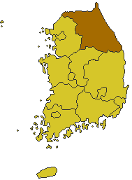
Would be less wasteful than creating a moster running from one end of the country to the other (Busan, below).

[/img] |
|
| Back to top |
|
|
reactionary
Joined: 22 Oct 2006
Location: korreia
|
| Posted: Wed Jan 09, 2008 9:17 pm Post subject: |
|
|
Could be due to lobbying by Pusan - maybe they want to retain some semblance of being the biggest port.
However, still an immensely stupid idea. We're not talking Panama here wedged between two huge continents - we're talking about the tiny-ass korean peninsula. |
|
| Back to top |
|
|
RACETRAITOR
Joined: 24 Oct 2005
Location: Seoul, South Korea
|
| Posted: Wed Jan 09, 2008 9:25 pm Post subject: |
|
|
| dalpengi wrote: |
Any reason why a canal couldn�t be built linking Seoul with the Sea of Japan/East Sea via Gangwon-do |
Have you seen the terrain over there? |
|
| Back to top |
|
|
dalpengi
Joined: 08 Dec 2006
|
| Posted: Wed Jan 09, 2008 9:47 pm Post subject: |
|
|
I have never been there but I know it is fairly mountinous. Wasn�t sure to what degree and to what degree it would complicate building a canal.
So, I take it is impossible, or at least would not be easier than building all the way to Busan? |
|
| Back to top |
|
|
dalpengi
Joined: 08 Dec 2006
|
| Posted: Wed Jan 09, 2008 9:53 pm Post subject: |
|
|
Yeah, it looks like it would be a bit of a challenge.
 |
|
| Back to top |
|
|
dalpengi
Joined: 08 Dec 2006
|
|
| Back to top |
|
|
kiwiduncan
Joined: 18 Jun 2007
Location: New Zealand
|
| Posted: Wed Jan 09, 2008 10:14 pm Post subject: |
|
|
The 'canal' will for the most part actually be two rivers (The Han that goes north to Seoul and the NakDong that goes south to Busan) connected with a real canal dug somewhere in the middle of the country. I understand the length of entirely new, artificial waterways is only about 20 to 40km.
Having said that, they are going to have to seriously mess up the natural Han and Nakdong river systems with dredging, groynes, reservoirs, locks and other features in order to make the entire system navigable, hence the opposition from environmentalists and skepticism from economists.
If I was an international investor I wouldn't touch this project with a barge pole. |
|
| Back to top |
|
|
davai!

Joined: 04 Dec 2005
Location: Kuwait
|
| Posted: Wed Jan 09, 2008 10:52 pm Post subject: |
|
|
in case anyone else was wondering....  (wikipedia) (wikipedia)
| Quote: |
Groyne
A groyne (groin in the United States) is a rigid hydraulic structure built out from the shore (in coastal engineering) or from the bank (in rivers) and interrupts the flow of water and sediment. Groynes serve a multitude of functions.
In coastal engineering
Groynes are one of the most common and effective methods of coastal defense against transportation of sediment. Groynes are structures which run perpendicular to the shoreline. Groynes extend from the upper foreshore or beach down towards the sea, usually at right angles to the sea. Groynes are usually made of wood, concrete, or piles of large rocks. Groynes are generally constructed in groups called groyne fields.
The length, elevation, and spacing between groynes should be determined according to local wave energy and beach slope. Groynes that are too long or too high tend to accelerate downdrift erosion because they trap too much sand. Groynes that are too short, too low, or too permeable are ineffective because they trap too little sand. Flanking may occur if a groyne does not extend far enough landward.
Groynes are extremely cost-effective, requiring little maintenance, and are one of the most common coastal defence structures. However, groynes are increasingly viewed as making the coastline look unnatural and ugly, and are opposed by many people. Groynes are very often used in tandem with seawalls to provide a very effective means of coastal defence.
How groynes work
The purpose of a groyne is to create and maintain a healthy beach on its updrift side, which in turn provides protection to the land behind. These effects are achieved through two main processes. First, groynes act as a barrier to physically stop sediment transport (sand) in the direction of longshore transport through the system. This causes a build-up of the beach on the groyne's updrift side. Secondly, groynes interrupt the tidal flow forcing the tidal current further offshore beyond the groyne end. This slows the tidal current inshore causing the deposition of heavier sediments and encouraging the beach to grow in size. However, this is often accompanied by accelerated erosion of the downdrift beach, known as terminal groyne syndrome, as it occurs after the terminal groyne, which receives little or no sand via longshore transport. (It is important to realize that groynes do not add any new sand to the beach, but merely retain some of the existing sand on the updrift side of the groin.) If a groyne is correctly designed, then the amount of material it can hold will be limited, and excess sediment will be free to move on through the system. However, if a groyne is too large it may trap all sediment reaching it and this can cause severe beach erosion problems on the down-drift side, which in turn can result in coastal erosion problems. Ά
In rivers
Groynes (often referred to as "spur dikes" or "wing dykes"), are often constructed (nearly) perpendicular to the river banks, beginning at the riverbank with a root and ending at the regulation line with a head. They serve to maintain a desired channel for the purpose of preventing ice jamming, improved navigation and erosion control over lateral erosion, that would form Meanders. Groynes have a major impact on the river morphology; generally speaking, they cause autonomous degradation of the river. The areas between the groynes are referred to as groyne fields.
|
|
|
| Back to top |
|
|
uberscheisse
Joined: 02 Dec 2003
Location: japan is better than korea.
|
| Posted: Wed Jan 09, 2008 11:01 pm Post subject: |
|
|
seoul-busan on a bus, 5-6 hours.
seoul-busan in a canal boat/barge, 5-6 months.
moronic idea. |
|
| Back to top |
|
|
kiwiduncan
Joined: 18 Jun 2007
Location: New Zealand
|
| Posted: Thu Jan 10, 2008 6:57 am Post subject: |
|
|
From the canal opposition website here is a map of the course of the proposed canal.
 |
|
| Back to top |
|
|
IncognitoHFX

Joined: 06 May 2007
Location: Yeongtong, Suwon
|
| Posted: Thu Jan 10, 2008 8:28 am Post subject: |
|
|
| kiwiduncan wrote: |
From the canal opposition website here is a map of the course of the proposed canal.
|
Wicked! So can I use my T-money card on it? |
|
| Back to top |
|
|
|
|
You cannot post new topics in this forum
You cannot reply to topics in this forum
You cannot edit your posts in this forum
You cannot delete your posts in this forum
You cannot vote in polls in this forum
|
|


